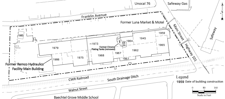
Former Remco Hydraulics FacilityThe Former Remco Hydraulics Facility located at 934 S. Main Street is an elongated, fenced parcel of approximately seven acres, located immediately adjacent to and west of U.S. Highway 101 (Main Street) in the southern portion of the City of Willits. The original Facility building was constructed on the property in 1945. The building was expanded over time to accommodate a growing industrial machining and manufacturing business, which was operated under numerous owners from approximately 1945 until 1995. Chrome plating operations were conducted from approximately 1963 through 1995 at the Facility. The last owners, Remco Hydraulics, Inc. and its parent company, MC Industries, both declared bankruptcy in 1995 and the Facility was closed in 1996. Since established in 1997, the Willits Trust has conducted substantial work to investigate and cleanup the Site. The primary chemicals detected at the Remco Site are volatile organic compounds (VOCs) and hexavalent chromium. In addition, other metals, petroleum hydrocarbons, polyaromatic hydrocarbons (PAHs), and polychlorinated biphenyls (PCBs) have been detected in a more limited basis at the Remco Facility. The Willits Trust has completed the characterization of the lateral and vertical extent of these chemicals at the Remco Site and prepared a Remedial Investigation Report (RI Report) documenting these findings. In addition, the Willits Trust has continued to routinely monitor groundwater, storm water and surface water at the Site. Following completion of the RI Report, the Willits Trust prepared a risk assessment to evaluate current and potential future risks associated with exposure to groundwater at the Site and prepared a feasibility study evaluating alternative remedial actions and recommending final remedial actions for the Site. During the characterization of the Site and preparation of reports, the Willits Trust has made substantial progress at cleaning up the site through the implementation of interim remedial actions. Further information regarding these activities can be found on the Document Depository. |
Community Toll-Free Line
877.333.0804
|